Wednesday, 13 July 2016

Naturescape: Brachyleptura rubrica

Brachyleptura rubrica, like dozens of other longhorn beetle species, are important pollinators. This one is covered in Spotted Water Hemlock (Cicuta maculata) pollen.
Photo: Mark Conboy

Designer Forests

Pawpaw (Asimina triloba) produce the largest fruit of any native North American tree and were probably widely planted and cultivated by first nations people.
Illustration: Mark Catsby

I live minutes away from one of the most biologically diverse patches of old growth forest remaining in Canada. It's a green paradise of endangered Tulip Trees (Liriodendron tulipifera) and imperiled Butternuts (Juglans cinerea), massive American Beeches (Fagus grandifolia), impressive Basswoods (Tilia americana), generous Black Cherries (Prunus serotina), large Large-toothed Aspens (Populus grandidentata), ancient Sugar Maples (Acer saccharum), giant Black Maples (Acer nigrum), sky-high Northern Red Oaks (Quercus rubra), jumbo Eastern Black Oaks (Quercus nigra), broad Common White Oaks (Quercus alba), shaggy Shagbark Hickories (Carya ovata), bitter Bitternut Hickories (Carya cordiformis), stately Black Walnuts (Juglans nigra), substantial White Ashes (Fraxinus americana), towering Yellow Birches (Betula alleghaniensis), shady Eastern Hemlocks (Tsuga canadensis) and wind-sculpted Eastern White Pines (Pinus strobus). Tangled River Grape (Vitis riparia) vines drape over limbs high above the forest floor, while tenacious Poison Ivy (Toxicodendron radicans) and tendrilous Virginia Creeper (Parthenocissus quinquefolia) climb up trunks. Diminutive American Chestnuts (Castenea dentata), fragrant Sassafras (Sassafras albidum), strong Blue-Beeches (Carpinus caroliniana), superstrong Ironwoods (Ostrya virginiana), beautiful Eastern Flowering Dogwoods (Cornus florida), oriental Pagoda Dogwoods (Cornus alternifolia), spreading Witch-Hazel (Hamamelis virginiana), spicy Spicebush (Lindera benzoin), and rare Wahoo (Euonymus atropurpurea) fill out the understory. Slender Black Gums (Nyssa sylvatica), regal Swamp White Oaks (Quercus bicolor), girthy Bur Oaks (Quercus macrocarpa), huge Red Maples (Acer rubrum), stupendous Silver Maples (Acer saccharinum), hefty White Elms (Ulmus americana), modest Slippery Elms (Ulmus rubra) and robust American Sycamores (Platanus occidentalis) ring salamander breeding ponds. Quiet and solitude pervade. In this place, it's tempting to think that this remnant forest is a pristine urwelt, untouched since glacial times. But that's simply not the case; humans have been influencing and impacting the forests in one way or another since time immemorial, including this one.

Since the arrival of Europeans in the Americas, forests have suffered tremendously. In my own patch of forest I see evidence of overharvesting of "medicinal" plants, namely American Ginsing (Panax quinquefolius); recreational vehicle damage; overgrazing by White-tailed Deer (Odocoileus virginianus) caused by poor management practices; the historical overhunting of fur and game animals which has left the woods impoverished of Fisher (Martes pennanti) and Elk (Cervus canadensis) and a host of other species; fragmentation by roads; increased incidences of Brown-headed Cowbird (Molothrus ater) parasitism on nesting birds because of reduced forest area; artificial drainage ditches; sterile conifer plantations; dozens of devastating introduced species like Chestnut Blight (Cryphonectria parasitica), Emerald Ash Borer (Agrilus planipennis) and Garlic Mustard (Alliaria petiolata); forest fire suppression; and the extirpation of top predators like Grey Wolf (Canis lupus). Other forests are impacted still further by industrial and selective forestry, clearing for agriculture, overgrazing by domestic livestock and fragmentation by pipelines, power transmission lines and seismic lines. Most of these impacts would be considered European in origin, perhaps with the exception of clearing land for agriculture. But first nation, especially along the St. Lawrence River and around the Great Lakes, were influencing and impacting forests, sometimes in extreme ways, long before the arrival of European explorers and settlers.


A farmstead carved out of Carolinian old growth near Chatham, Ontario, circa 1838.
Painting: John Philip Bainbrigge

The "untouched" forests that Europeans encountered in the Great Lakes basin were in many cases actually more like carefully designed landscapes, and not deep dark wildernessesFirst nations people cleared forests for agriculture, sometimes on impressively grand scales, using fire and by girdling large trees. The fields were then planted up with Corn (Zea mays), beans, squash, tobacco and other medicinal and edible plants. After a decade or so, as local resources such as firewood, game animals and soil quality diminished, settlements were relocated, and fields were burned and left to regrow under natural succession. Where forests were left intact, controlled burns, usually in the form of modest ground fires, were used to clear forest understory of thick shrubs and forbs, promoting the growth of grasses and other forage favourable to game animals. Managing habitat with fire may have imperative to maintaining sustainable game populations around settlements since hunting pressure would have been intense. The legacy of these impacts is difficult to detect in forests today without diving into the pollen or charcoal records of a forest. There is another way, however, that first nations historically influenced forest ecology: sylvaculture of fruit- and nut-bearing trees; in some cases, we can still see evidence of that on the landscape today.

Doubtless, sylvacultural techniques would have differed culturally and geographically, but in general it seems to have included both the management of existing forests to promote the growth of productive old trees, and the planting of new trees in orchards. It was chiefly centered around settlements, where foods could be easily harvested and protected against pests and, no doubt, other humans. Pawpaw (Asimina triloba)oaks, Shagbark Hickory, Shellbark Hickory (Carya laciniosa), Pecan (Carya illinoinensis), American Chestnut, Allegheny Chinquapin (Castanea pumila), hazels, Black Walnut, Butternut, and American Beech were all utilized as food, and may all have been part of sylvacultural practices throughout eastern North America. The reality is, we don't know much about  historical first nations sylviculture, but what evidence we do have comes mainly from studies of witness tree records in the United States. Witness trees were trees marked and noted by surveyors as they laid out plots of land. In theory, witness trees should be representative of the relative abundance of species that were present when surveyors moved through a region, usually sometime in the 1700's and 1800's. Surveyors would have marked whatever tree was closest to corners of the lots they were mapping, so trees were essentially selected randomly (though some bias for selecting trees of certain size or species may have existed). Thanks to this historic record, ecologists have been able to show that a disproportionate number of witness trees around known former first nations settlements are nut-bearing trees.

First nations people may have reduced competition around nut-bearing trees by girdling or otherwise removing adjacent competitors. They also planted trees around settlements, sometimes in large orchards, if historical accounts are accurate. In the course of establishing orchards, trees were sometimes moved well beyond their normal range. I suspect that the few Shellbark Hickories near Long Point, Ontario, may have been moved there (as nuts) by first nations people; the massive nuts of Shagbark Hickory are not likely to have been transported by wildlife over such a long distance from the next nearest populations: 135 km away on the Niagara Peninsula and 200 km away in Essex County. A similarly disjunct population of Pawpaws, again near Long Point, may have been established in the same way. Pawpaw produces the largest fruit of any native tree in North American and were certainly utilized by first nations south of the Great Lakes, so would have been a likely candidate for human-facilitated range expansion. In my childhood haunts of eastern Ontario, there is an isolated population of Bear Oak (Quercus ilicifolia), 200 km distant from the next nearest population in New York State, which is itself disjunct from the species' main range by a similar distance. Was this species brought to eastern Ontario by first nations people? Bear Oak isn't known to have been a particularly important food source, compared to Common White Oak for example, but Bear Oak acorns may have been accidentally transported along with other oaks and either discarded to grow feral or intentionally planted.

I would say that not enough consideration has been given to the influence of first nations on the abundance and distribution of fruit- and nut-bearing trees in North America. Though quantitative evidence is limited, it stands to reason that since other cultures all over the world have been moving useful and valuable plants around the globe for millennia, native Americans would have done the same. Certainly, other first nations' practices such as the widespread use of fire to modify landscapes, has been well documented. The historical legacy of fire use is now being considered in such a way as to cause us to redefine what we mean by untouched wilderness. Very few places on Earth are true wildernesses, truly untouched. Rather, almost everywhere that can support a viable ecosystem has been home to humans at one time or another, and humans, no matter how limited their population, or how conservation-oriented their society is, invariably impact and influence ecosystems in measurable ways. It's time to start looking at humans, both historic and contemporary, as part of forest ecology, not a separate and unnatural or external influence. Only once the human dimension is considered, can we hope to have a complete historic view of forests, and a more holistic approach to addressing modern day conservation concerns.

Sunday, 3 July 2016

Lake Erie's Hidden Hydrocarbons

Beneath Lake Erie is a wealth of oil and natural gas, giving rise to an industry that many local people don't realize exists in their own backyards.
Photo: Mark Conboy

I came to live on Lake Erie a year and half ago. After a term as an environmental consultant working on various oil and gas developments in Alberta, I decided that an industrial job and big city life weren't ideal, so I said goodbye to the boreal forest, the Rocky Mountains, the great spreading plains, and moved east, far from the oil and gas heartland. But I was very soon to realize that Lake Erie, was in fact an oil and gas hub all its own.

Now, this wasn't a total surprise, but it was something I hadn't really considered. I knew, of course, that Canada's first hydrocarbon company had been established to make asphalt from near-surface tar deposits at Petrolia, Ontario. By 1858, the first true oil wells in all of North America were dug in southern Ontario near the town of Oil Springs (it wasn't until the following year that the American oil crazy took off when Edwin Drake famously drilled into a pressured reservoir at Oil Creek, Pennsylvania). The sight of oil pumpjacks and natural gas well heads spread out across the countryside was nothing new to me either. But, I admittedly got a big surprise when I unfolded a nautical chart of Long Point Bay, and saw the maze of pipelines which crisscrossed the lake bed, connecting dozens of gas wells. It had never occurred to me, that there was an offshore hydrocarbon industry on the Great Lakes. Then again, why shouldn't there be? Offshore ocean oil and gas industries exist all over the world, and with oil and gas deposits to the north and south of Lake Erie, it should have been obvious.

But the offshore oil and gas industry on Lake Erie isn't obvious. There are no permanent oil platforms. Natural gas drilling rigs are modest-sized barges that only take a week or so to dig a well and bring it into production, so their presence on the lake is not all that intrusive. Well heads and pipelines lay on the bottom of the lake, completely out of sight, aside from the small white buoys that mark their presence. Indeed, many people who live on Lake Erie have no idea that an offshore oil and gas industry exists.

There are close to 500 natural gas wells (and far fewer oil wells) currently in operation on the Canadian side of Lake Erie, though several thousand have been drilled since production began in 1913. In fact, almost the entire offshore oil and gas industry is based on the Canadian side of the Great Lakes. The only state which currently allows offshore production is Michigan, but all of the wells under Lake Michigan are drilled from shore. In Ontario, oil is harvested from Lake Erie using the same kind of shore-based technique, called directional drilling. This involves drilling vertically to desired depth, then drilling horizontally under the lake bed, sometimes for many kilometres, through the oil-containing rock formation. Once a well is operational, the oil is pumped directly back to shore. In this way, the risk of an oil spill is kept to an absolute minimum. Typical drilling for natural gas uses another approach. In this case specialized barges drill vertically into the lake bed. Once the drilling is done, the well is capped and connected to shore via a pipeline. There are some 890 km of pipelines in operation under Lake Erie today. Some directional drilling may be employed for natural gas as well, but given the reduced environmental contamination risks of natural gas, most drilling can safely occur offshore. Most wells are expected to produce for 10-20 years.


Major oil and natural gas pipelines in Lake Erie.

Map: Offshore Magazine

Lake Erie oil and gas is extracted from Silurian aged rocks, 419-444 million years old. When these rocks formed, Ontario was a very different place. The province was located some 6000 kilometres south, at approximately the same latitude where Bolivia sits today. Though having the enviable geography of a tropical paradise, Silurian Ontario would have been amazingly devoid of terrestrial life, because it would still be another few hundred million years before land plants and animals became abundant. Silurian ocean life was plentiful however, with fish diversifying rapidly and microscopic marine algae providing the foundation for food webs, just as it does today. For at least part of the Silurian, southern Ontario was covered by a relatively shallow tropical sea. It was from this sea that Lake Erie's oil and gas deposits arose. Dead organic materials, in this case Silurian marine algae and animals which become buried under layers of sediment are transformed into oil over millions of years through exposure to phenomenally high temperatures and pressures. Over time, exposure to heat and pressure chemically alters the trapped organic material, turning it into oil. In effect, when we use Lake Erie oil for fuel we are essentially burning ancient algal blooms, with perhaps a smattering of fish, sea scorpions, crinoids, mollusks and brachiopods mixed in. Natural gas that is harvested from beneath Lake Erie was formed in the same way oil, but gas can also be formed through the anoxic decomposition of organic matter under much simpler conditions such as in a bog or swamp, and during digestion by animals. Even humans create their fair share of natural gas; natural gas is simply methane, after all.

The Silurian rocks which contain Lake Erie's oil and gas are buried between 100 and 1100 meters below the lake bottom. Two types of natural gas are produced: at the eastern end of the lake sandstones and shales produce sweet gas, or natural gas that doesn't contain poisonous foul-smelling hydrogen sulfide. In the western half of the lake a series of ancient patch reefs, 10-40 metres thick produce sour gas, natural gas which does contain hydrogen sulfide. It's not uncommon for people to picture reservoirs of oil or gas as underground lakes. But that's not the way it is at all, in fact, the oil and gas are within the rocks themselves, filling tiny pores. The sandstones and shales, which are made of compacted and lithified Silurian sand and mud, respectively, are full of pores and those pores are full or oil and gas. The oil and gas didn't form inside those pores, but migrated there from their over long periods of time from its original location. Just as coffee percolates through a filter, oil and gas percolate their way through porous rock formations, some escaping to the surface, some getting trapped under impermeable layers of rock building up in large enough quantities for us to extract it economically. The formation of oil and gas deposits is a surprisingly dynamic process, only it takes place over such extraordinary timescales that it seems static from the typical human perspective. 

Compared to Alberta, Ontario's oil and gas industry is tiny. Virtually all of the production from Lake Erie's oil and gas fields is used in Ontario, but that only amounts to 1% of the province's annual oil consumption and 2% of annual gas consumption. Small potatoes. And thank goodness for that. Because, no matter how carefully an industry is regulated and no matter how much effort is made to reduce the risk of environmentally damaging oil spills, accidents do happen and when they happen in an offshore environment they can devastate ecosystems and be all but impossible to clean up. Spills and leaks seem to be relatively uncommon but they do occur in Lake Erie from time to time. Coming up with exact numbers for recent years isn't easy, but there are always a couple of small incidents annually.

Beyond the problem of oil spills and gas leaks, sedimentation, primarily from drilling waste, is another potential environmental concern. When wells are drilled, tailings in the form of sand, mud, rock particles and drilling fluids are released into the lake, where they can cause localized sedimentation. Whether this is a major problem for wildlife is unclear, but given that less than one hundred new wells are dug in the average year on Lake Erie, it probably is not. Compared to the uncounted tonnes of sand that is carried around the lake naturally by winds, currents and erosion, the harm caused by drilling sediment must surely be negligible, or at least very localized. That being said, drilling fluids do contain chemicals that are known to be harmful to humans, and unfortunately they are released (at least in some cases) directly into the lake; why exactly this is allowed and what health consequences may result is unclear.

Although Alberta (and to a lesser extent British Columbia and Saskatchewan) is the focus of Canada's oil and gas industry, southern Ontario is its birthplace. Lake Erie's small but sustained production has, for better or worse, kept the industry alive in Ontario for more than a century, even if it is relatively unknown.

Tuesday, 28 June 2016

Fish of the Forgotten North

Lake Cisco (Coregonus artedi)
Illustration: Ellen Edmonson and Hugh Chrisp (Wikimedia Commons)

Ontario's far north, that area above an imaginary line running from Woodland Caribou Provincial Park in the west to Natogami Lake in the east, comprises 42% of the province. At 451,920 square kilometres, that's a huge area. It's bigger than the UK. It's bigger than Romania. It's bigger than all three maritime provinces combined. Big, but easy to overlook if you're not one of the 0.2% of Ontarians who live there, or one of the lucky southerners who has visited this intractable miasma of forest, muskeg and tundra. Most southerners never give a moment's thought to the province's far north, nor its 1210 km of saltwater coastline. But there it sits, in all its subarctic glory, even if it is more or less forgotten by the vast majority of Ontarians.

If you've lived, worked or played in Ontario's far north, you know that in reality it's anything but forgettable. It's vast, and wild. It's a place where wildfires are often allowed to rage unchecked, where the forces of nature rule. Roads are few and mostly winter access only. Settlements are small, scattered and have only limited access to outside resources. In the dead of winter the forests are eerily silent and temperatures can be devastatingly cold. In summer the land bursts with life, which would be paradisaical if it weren't for the uncounted hordes of biting flies. Wildlife abounds, but given the immensity of the landscape, can be difficult to find. In the far north, the rest of the world seems very far away.

I've been lucky enough to enjoy two visits in recent years: once to the vast and sweeping tundra-treeline ecotone of Hudson Bay's Polar Bear Provincial Park; and once to the coastal wetlands, forested ridges and tidal flats of southern James Bay. But even after two visits chasing Nelson's Sparrows (Ammodramus nelsoni), Yellow Rails (Coturnicops noveboracensis), Northern Fulmars (Fulmarus glacialis), Smith's Longspurs (Calcarius pictus), Polar Bears (Ursus maritimus), Arctic Foxes (Vulpes lagopus), Caribou (Rangifer tarandus), Melissa Arctics (Oeneis melissa), Azure Darners (Aeshna septentrionalis), 'Hudson Bay' American Toads (Anaxyrus americanus copei) and dozens of other unusual (for Ontario) species, I've come to realize that there's one aspect of the far north's natural history that I still have almost no knowledge of: the marine fishes.

Ontario's Hudson Bay coast is home to very few people and is visited by fewer still. Cree hunters built these cairns in Polar Bear Provincial Park. Ice still lingers offshore in this June photograph.
Photo: Mark Conboy

Ontario's saltwater coast represents the southernmost extension of Hudson and James Bays, which together form the largest discrete body of water on Earth that completely freezes in winter and completely thaws in summer; ice cover lasts from December to May or June. As in any northern waters, ice plays a significant role in the lives of fish.

Marine fish live in a supercooled world, a world of liquid ice, in a sense. That's because saltwater has a freezing point of roughly -1.9 degrees Celsius. But that's an extremely challenging environment for fish to live in, requiring a whole suite of enzymes and other molecules that can function below the temperatures experienced by organisms in more benign environments. Furthermore, fish have a freezing point which is slightly above that of seawater. As a result, fish that are living in seawater could actually freeze solid before the water that surrounds them does. Some species get around this problem by migrating to deeper waters where ice doesn't form, owing to increased water pressure. A descent below 30 metres depth is usually sufficient to avoid freezing.

Other fish remain near the surface and have developed another strategy to avoid freezing: antifreeze proteins. Antifreeze proteins bind to rudimentary ice crystals, essentially coating them, and inhibiting further growth of those crystals. There are at least half a dozen known antifreeze proteins at work in arctic and antarctic fish. Because the proteins inhibit the growth of ice crystals, fish can live in shallow supercooled environments without the risk of turning into fishcicles.

Rivers such as Ontario's Winisk, Severn, Attawapiskat, Albany, and Moose are just as influential as ice is in determining the region's ecology. The estimated 750 cubic kilometres of freshwater that these and other rivers in Manitoba, Nunavut and Quebec pour into the bays annually, drastically lowers salinity levels across this relatively small oceanic basin. Consequently, fish diversity in the bays is a mixture of truly marine species and normally freshwater species that can live in the much reduced salinity.

Rivers bring such a tremendous amount of freshwater into the bays that one Canadian engineer has devised the Great Recycling and Northern Development Canal, an ill-conceived megaproject that calls for the construction of a dam across the mouth of James Bay to keep saltwater out, while allowing the ample inflow from rivers to eventually turn the bay into a massive freshwater lake. A canal would then be constructed to carry water south into the Great Lakes where it would be used to bolster water supplies in other parts of the continent. Such a scheme would irrevocably affect the region's ecology and would be an environmental disaster of nearly unparalleled proportions, but the fact that such a project would even be conceived of serves to underscore just how much freshwater enters the bays every year.

There are perhaps as many as 61 fish species in the bays, with about 53 of those known from southeastern Hudson Bay and James Bay; about half of them are strictly marine, while the rest are amadromous, spending at least part of their lives in freshwater or brackish estuaries. How many species regularly occur off Ontario's coast is a little unclear, but there are at least 20.

Indeed, when it comes to Ontario's saltwater coast, there is a lot that remains unclear. Relatively little is known about fishes in our forgotten north, because research has been rather limited. That's not to say that no research has been conducted. Early twentieth century expeditions were sent to Hudson Bay to determine any potential for establishing commercial fisheries there. No such potential was found. Even today, when it seems humans have managed to exploit virtually every corner of the Earth, there is still no true marine fishery in the bays. A small amount of commercial fishing, mainly limited to Arctic Char (Salvelinus alpinus) occurs along the Nunavut and Nunavik (northern Quebec) coasts. These harvests are relatively small, more akin to subsistence fisheries than full-scale commercial harvests, and are confined to rivers, not the bays themselves. The lack of a commercial fishery in the bays is probably one of the major reasons for the research deficit. But one area where there has been particular research interest is in understanding the impacts of hydroelectric development on amadromous species, particularly on the Quebec side of James Bay.

We do have a good understanding of which species are most common and widespread and which species are of prime ecological importance. Of the truly marine species, Arctic Cod (Arctogadus glacialis), Capelin (Mallotus villosus) and Pacific Sand Lance (Ammodytes hexapterus) are among the most significant. Arctic Cod have long been a food source for people living on the Belcher Islands off the coast of Quebec (the Belcher Islands are actually part of Nunavut, and so are all other islands in Hudson and James Bays), but have apparently never represented a significant subsistence fishery off the Ontario coast. Another cod, the similar but non-gregarious Greenland Cod (Gadus ogac) occurs in eastern James Bay but, interestingly, seems to be more or less absent from the Ontario coast. Belcher Islanders have also traditionally harvested Capelin where they spawn off shallow beaches, but again this species has never been harvested in significant quantities off the Ontario coast. Pacific Sand Lance have the curious behaviour of burying themselves in the benthos where they can even survive above the low tide line. Arctic Cod, Capelin and Pacific Sand Lance all school in large numbers and are the ecological cornerstones of Canada's arctic and subarctic marine environments, representing a significant food source for other fish, mammals and seabirds. Their importance off the Ontario coast is probably similar to elsewhere in the bays, but the extent to which that has been studied seems to be very limited.

Twohorn Sculpin (Icelus bicornis), Fourhorn Sculpin (Myoxocephalus quadricornis), Arctic Sculpin (Myoxocephalus scorpioides), and Shorthorn Sculpin (Myoxocephalus scorpius) are also marine inhabitants of Ontario's coast. Interestingly, there is a documented case of a young male Polar Bear (Ursus maritimus) diving for and catching Fourhorn Sculpin and Arctic Charr, making those the only two species the only fish for which Polar Bears have actually been documented to hunt; they normally focus on seals.

The Arctic Alligatorfish (Aspidophoroides olrikii) sounds formidable in name but only ever reaches a maximum length of 10 cm and feeds on tiny prey such as amphipods and ostracods. The woefully named Lumpfish (Cyclopterus lumpus) was long thought to be a primarily benthic species, with its suction cup-like pelvic fin and lack of swim bladder, but in reality it also seems to spend a great deal of time in the water column. Lumpfish, at one time were part of a fishery in Newfoundland and Labrador, where considerable numbers were taken for their nutritious row. The species has declined considerably in eastern Canada and is not fished as heavily anymore. Although it is fished in Greenland, it has never become a commercial species in Hudson or James Bays. Similar to the Lumpfish is the Leatherfin Lumsucker (Eumicrotremus derjugini). The lumpsucker is a true bottom-dweller, and it too is without a swim bladder but has a suction cup-like pelvic fin for anchoring to the bottom as an adult and to seaweed mats or other drifting debris as a juvenile. There's also the relatively little known, but widespread Variegated Snailfish (Liparis gibbus) and the Fourline Snakeblenny (Eumesogrammus praecisus). No sharks penetrate into southern Hudson Bay or James Bay, only the Greenland Shark (Somniosus microcephalus) reaches the northern parts of Hudson Bay and the deeper waters of the Hudson Strait.


A juvenile Lumpfish (Cyclopterus lumpus) using its suction cup-like pelvic fin to adhere to a piece of seaweed.
Photo: Hans Hillewaert (Wikimedia Commons)

The list of truly marine species is relatively short. But marine fish are only part of the piscean picture. In James Bay in particular, anadromous freshwater species form a significant portion of the diversity. Anadromous species spend at least part of their life cycle in freshwater, usually rivers, and part of their life at sea (or in large lakes, such as with many Great Lakes species). Lake Cisco (Coregonus artedi), Lake Whitefish (Coregonus clupeaformis), Round Whitefish (Prosopium cylindraceum) and Longnose Sucker (Catostomus catostomus) are commonly found in James Bay for at least part of their life cycles. Burbot (Lota lota) and Lake Trout (Salvelinus namaycush) are less common. Seldom do any of these species use saltwater in most other parts of their range. But in James Bay, the low salinity levels from river inflows means that these normally freshwater fish can survive. But all of these species become rarer in Hudson Bay, where salinity increases to intolerable levels.

Among anglers, perhaps the most notable of Ontario's northern amadromous fish is Brook Trout (Salvelinus fontinalis). Not normally thought of as an ocean fish, but rather one of streams, rivers and cold lakes, there are some populations that are amadromous (in the maritime provinces they're called salters). Both the typical permanently freshwater form and the amadromous form can be found in Ontario's Hudson Bay Lowlands, but of course, its only the salters that reach the bays themselves. These trout spend the first 2-4 years of their life in freshwater, before going to sea for 2-4 months, and then returning to freshwater to spawn. While at sea, Ontario salters lose their bright red colours, becoming silvery. Their vibrant colours return once they retreat to freshwater. The related Arctic Char also has permanently freshwater and anadromous forms throughout much of its range, though only the anadromous form is thought to occur in Ontario, and then only rarely.

Other freshwater species are found in James Bay from time to time, including Walleye (Sander vitreus), White Sucker (Catostomus commersonii), Slimy Sculpin (Cottus cognatus), Spoonhead Sculpin (Cottus ricei), Brook Stickleback (Culaea inconstans), Threespine Stickleback (Gasterosteus aculeatus), and Ninespine Stickleback (Pungitius pungitius). The latter two species are confined primarily to estuaries where the concentration of saltwater is lower still.

Unfortunately Hudson and James Bays have not been spared the scourge of introduced species. In a somewhat misguided attempt to artificially establish commercial and recreational salmonid fisheries, the eggs and fingerlings of Pink (Oncorhynchus gorbuscha) and Chum Salmon (Oncorhynchus keta) were introduced into several rivers in southern Hudson Bay and James Bay in 1955-56. Luckily none of the fish survived to found breeding populations. Another introduction to Hudson Bay has been the Rainbow Smelt (Osmerus mordax). Introduced for some confounded reason into river systems in northwestern Ontario, this species has spread into Manitoba and southern Hudson Bay. Rainbow Smelt are anadromous and gregarious. They consume the same planktonic and invertebrate prey as many native species, resulting in direct resource competition. Smelt themselves become prey for a multitude of other larger predatory species but many fishers claim that commercial and sport fish that feed on smelt spoil more quickly and taste poorly. Rainbow Smelt are not harvested in Hudson Bay or its tributaries, as they are in Atlantic Canada and on the Great Lakes.

There's still a great deal to learn about the fish of Ontario's saltwater coast. Perhaps the ever growing interest in arctic and subarctic ecosystems and the challenges they face from climate change will stimulate new research initiatives in our forgotten north. Until then, the vast northern coastline will remain as wild and elusive as ever.

Tuesday, 12 April 2016

A Winter Retrospective

Where I live, April has been as wintery as anytime in the past five months. Even now, it's snowing like crazy! In the spirit of this long-staying winter, I present a little photographic tribute to those dark and snowy days. Enjoy.
 

Long Point, Lake Erie. In summer, this stretch of beach is crowded with hundreds of sun seekers, but in mid winter it looks more like unexplored arctic coastline.
Photo: Mark Conboy

As ice begins to coat even the wavy waters of the Great Lakes, most waterfowl migrate away, but wherever there is even a little open water, there is sure to be some hardy stragglers, like this Redhead (Aythya americana).
Photo: Mark Conboy

Broad-leaved Cattails (Typha latifolia) after an eastern Ontario ice storm. Ice storms are a fact of life in southern Canada. They make for dangerous driving conditions and often lead to extensive blackouts, but they also transform nature into something unspeakably beautiful.
Photo: Mark Conboy

Sharp-tailed Grouse (Tympanuchus phasianellus) forage in a shallow coulee towards the end of a frigid day in southern Saskatchewan.
Photo: Mark Conboy
 
Saskatchewan's Grassland's National Park has a herd of free roaming Plains Bison (Bison bison bison). These massive bovids endure near ceaseless wind and extreme cold all winter long.
Photo: Mark Conboy
 
Normally a crepuscular hunter, this Short-eared Owl (Asio flammeus) was hunting Meadow Voles (Microtus pennsylvanicus) in broad daylight. Perhaps it was driven to hunt during the day by hunger, a constant fact of life for most wildlife that stays active during a Canadian winter.
Photo: Mark Conboy
 
A January Eastern White Pine (Pinus strobus) sunrise. Spending the night sleeping outside in winter is an acquired taste (and requires acquiring a certain skill set too), but it means you almost never miss a sunrise. There's no sight more pleasant than the rising sun after a long night of restless sleep in the deep freeze. But, as any winter camper will tell you, often the coldest part of the night is the hour right around sunrise. That's because the sun takes a while to heat the air and bring the temperature up. The sun is a welcome sight, but its warmth can be a long time coming.
Photo: Mark Conboy
 
A glacial erratic at rest on the algid shore of Amherst Island, Lake Ontario.
Photo: Mark Conboy
 
Periodic irruptions of Great Grey Owls (Strix nebulosa) into southern Canada offer the potential for turning a sometimes dismal season into something far more spectacular. Sometimes though, certain owls are repeatedly visited and even harassed by photographers, especially birds who set up winter quarters in or close to urban centres. Irruptions that bring owls south is a nice treat, but the real pleasure in finding a Great Grey Owl takes place deep in the wilderness of the boreal or montane forests, such as with this bird, which was photographed in northern Alberta.
Photo: Mark Conboy

Lichens provide winter-wary naturalists with a source of study, when most other organism are dead, absent or in hibernation.
Photo: Mark Conboy
 
Bohemian Waxwings (Bombycilla garrulus) are a fixture of prairie cities in winter, where upon leaving their boreal nesting grounds, they indulge in the often generous bounty of mountain-ash and other planted fruit trees found in cities. When I was a urbanite in Calgary, Alberta, my neighbourhood supported enormous flocks of waxwings, sometimes numbering in the thousands.
Photo: Mark Conboy

Ice. Living right on the Great Lakes means that fascinating ice formations are always present in winter. They never last long though; these petrified works of art are as ephemeral as anything in nature, forming and melting sometimes within the course of hours.
Photo: Mark Conboy
 
After an hour or so of following tracks through wonderfully deep snow, I was rewarded with a small flock of White-tailed Ptarmigan (Lagopus leucura) above Bow Summit in Banff National Park. Somehow ptarmigan had eluded me for the entire preceding summer, even though I transversed a few hundred kilometers of mountain terrain.
Photo: Mark Conboy

Forest Shadows in the mixed forests of the Frontenac Arch, one of Canada's most biologically rich regions.
Photo: Mark Conboy

Except for when they vocalize in late winter and early spring, Boreal Owls (Aegolius funereus) can be difficult to find. In some years boreals move into southern Canada, but in most years, this species remains in the boreal forest, eking out a living in the deep snow and suffocating cold.
Photo: Mark Conboy
 
A rare massive dump of snow in California's Mojave Desert.
Photo: Mark Conboy
 
Mudpuppies (Necturus maculosus) are the only amphibians that remain active in Ontario's winter. Indeed, they are at their most active during the coldest months, foraging on sluggish and sleepy prey such as aquatic insects and frogs.
Photo: Philina English
 
Facing the Pacific Ocean head on, Vancouver Island's west coast is renowned for its tremendous winter storms, which thrash and seethe along forested shores, like this one near Ucluelet.
Photo: Mark Conboy
 
British Columbia's temperate rainforests are world famous. But at higher elevations those forests might best be called snow forests. In the Coast Mountains, tremendous amounts of snow fall in most winters, with accumulations sometimes exceeding five metres, and the snow remaining on the ground into summer.
Photo: Mark Conboy

Snowy Owl (Bubo scandiacus), as true a winter bird as any other.
Photo: Mark Conboy
 
A gnarled and sagely Arbutus (Arbutus menziesii) stands up to an uncommon snowstorm on southern Vancouver Island.
Photo: Philina English
 
Frost-clothed greenery.
Photo: Mark Conboy
 
Western Red Cedars and Sitka Spruces become Christmas trees.
Photo: Mark Conboy
 
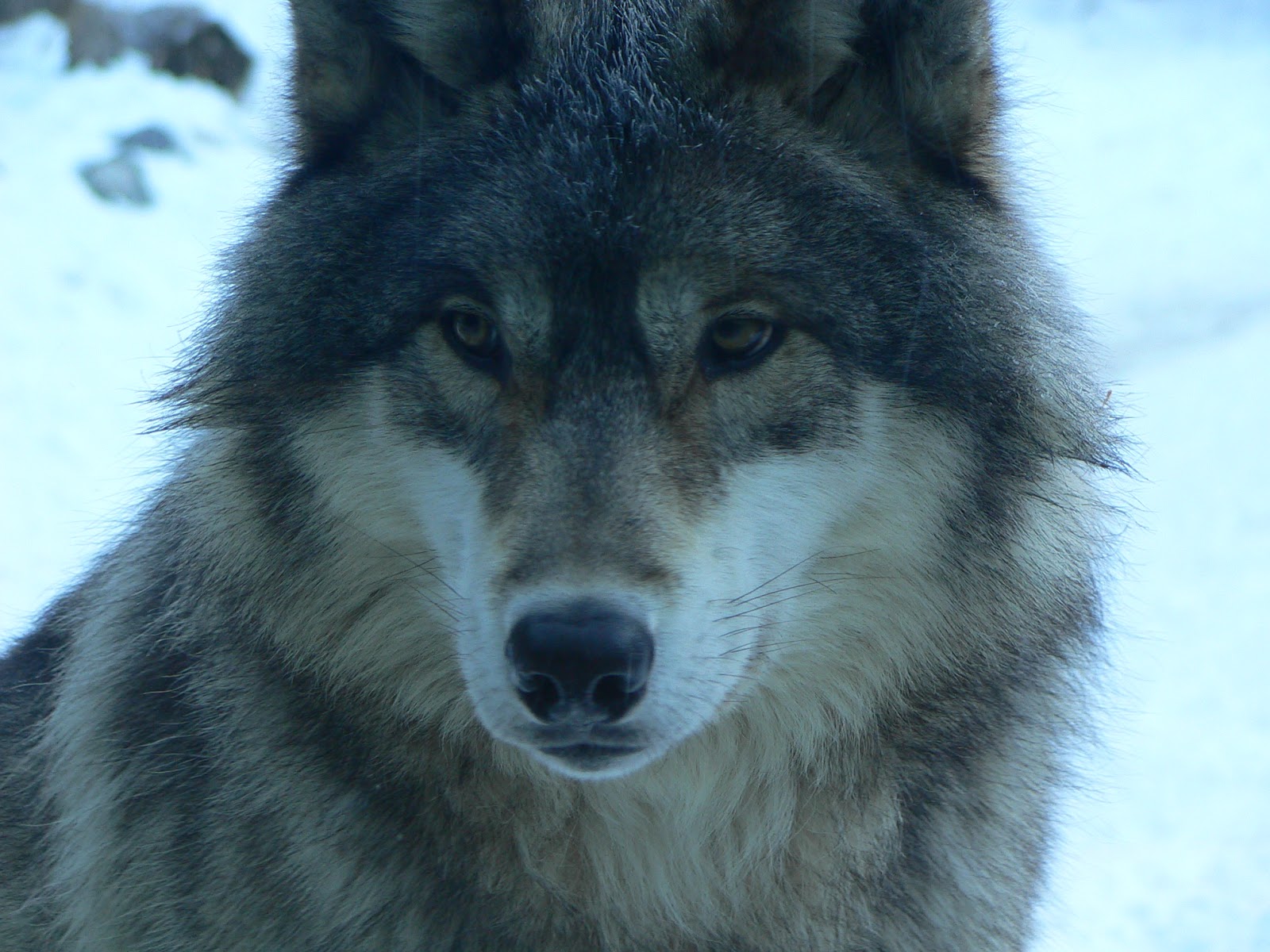
Grey Wolves (Canis lupus) can still be found in decent numbers throughout the boreal forest, where packs hunt Moose (Alces alces), Caribou (Rangifer tarandus) and Wood Bison (Bison bison athabascae), utilizing their superior endurance in deep snow to exhaust their enormous prey before closing in for the final kill.
Photo: Mark Conboy

A Northern Pitcher-Plant (Sarracenia purpurea) decorated with the winter's first frost.
Photo: Philina English
 
After a desperate night's sleep along the coast of Pukaskwa National Park, the day breaks bright and clear, but still senselessly cold.
Photo: Mark Conboy